
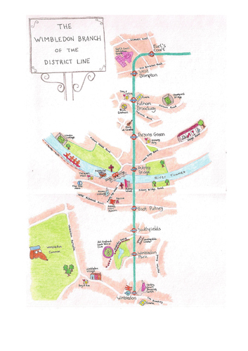
Gail Townsley sends us this delightful depiction of the District Line between Earl's Court and Wimbledon. In her own words:
I used to live in Putney and travel [this] section of tube twice a day every day so feel I know it, and the places of interest around the stations, rather well! As a cartographer you might think I have a head start on drawing a map, but I was amazed at how difficult it is to draw a map by hand. A digital map starts from the bottom and adds layers upwards from parks to water to roads to icons to text. A hand drawn map has to start with the top layer and fill in the background detail afterwards. Also there is no deleting or repositioning, or correction of spelling mistakes!
West London never looked so attractive.
Remember, the best entries in this series will be showcased in an exhibition at the Museum of London (in the main entrance foyer, and for up to six months!). If you fancy being part of that, get scribbling now. We're looking for hand-drawn depictions of London neighbourhoods, or London as a whole. Feel free to pick unusual themes or styles and don't worry if your artistry isn't perfect - ideas and humour are just as important. Send any entries to tips - at - londonist.com by the end of next week.
Previously: Angel to Bankside, Borough of Southwark, Brixton as a tree, Central London, Hampstead Heath, Central London with no street names, Driver's Mind Map, Fleet Valley, Hoxton Square, London as a grid, King's Cross and Islington, Mayfair, Mayfair Squares, New Cross, Notting Hill, Paris versus London, Patchwork London, Pimlico, River Fleet, Rivers, Stoke Newington, Stratford, Toilets, Walthamstow by mother and daughter, Westminster kettling.


